
A severe thunderstorm warning has been issued for parts of central and coastal Virginia, alarming residents with the threat of high winds, heavy rain, and potential tornado activity. As storm systems began to move through the area, officials are urging everyone to stay alert and prepared for the unexpected.
What’s Happening?
The National Weather Service notified citizens about the severe weather at 4:23 PM EST, making it clear that this storm is serious. Winds could gust up to 60 miles per hour and could cause damage to trees and power lines in places like Capeville, Birdsnest, and other communities in Northampton County.
- The warning was officially issued at 4:23 PM EST.
- The storms are racing northeast at 60 mph.
- Residents are advised to seek immediate shelter indoors.
- Local officials are closely monitoring the situation.
- Residents should prepare for potential power outages.
Winds and Rain Expected
As the storm approaches, it is anticipated that residents will experience high winds and intense rainfall. Radar visualizations show a storm system stretching from Willis Wharf to just south of Cape Charles, indicating widespread impact. Local authorities are on alert to help any residents in need and provide updates as the situation develops.
Residents Urged to Take Precautions
Officials stress the importance of safety during these storms. Families are encouraged to have an emergency plan, which includes where to go for shelter, keeping flashlights handy, and having a way to access emergency notifications. If you encounter downed power lines or flooding, reach out for help and avoid those areas.
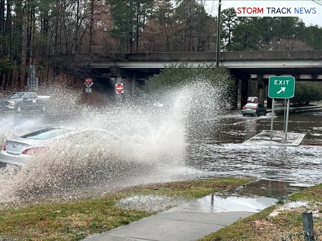
Flooding a Major Concern
In addition to wind and rain, flooding is also a significant hazard with these storms. Just recently, many areas have experienced road closures due to standing water, prompting residents to avoid driving in such conditions whenever possible. Roads can quickly become dangerous, and safety should always be the top priority.
Keeping Track of the Storm
To keep everyone informed, local news stations and the National Weather Service are doing their best to update the public on storm tracks in real-time. That way, communities can stay informed and take action as needed throughout the storm. It’s also a good idea for people to check the weather updates frequently, especially as severe thunderstorm watches are often updated, or changed as storms evolve.
What is a Severe Thunderstorm Warning?
A severe thunderstorm warning is more serious than a watch. It means that conditions are present that could produce storms capable of causing damage. This warning often includes potential tornado threats, damaging winds, and large hail, which can create hazardous conditions quickly. Understanding these differences can help you react effectively in times of severe weather.
| Storm Impact | Location | Expected Wind Gusts |
|---|---|---|
| Trees may fall | Northampton County | 60 mph |
| Road closures due to flooding | Widespread | – |
| Power outages likely | Impacted areas include several towns | – |

